Search This Blog

About Me

My photo
Panama, Panama, Panama
Greetings from Panama! My name is Marina Ehrman and I have been a professional tour guide and promoter for Panama Tourism and Travel Company since 2005. I love what I do and am proud to share what my country has to offer. It is filled with endless leisure and commercial attractions, friendly happy people who open their doors to all visitors. Panama is a country of incomparable natural beauty with a variety of tourist attractions, beautiful beaches in the Pacific and Caribbean. The tropical climate year round with its diversified flora, fauna and indigenous groups make it one of the most important of Ecotourism in Latin America. I invite you to know our country’s history, culture and also enjoy the cuisine, folklore and traditions that only a place in the world can provide………Panama! Contact me and I’ll organize your visit and will be happy to welcome you in Panama. For more information on Panama, follow my Facebook page and my blog. Visit www.panamatourismtravel.com

Goethals Memorial Monument

Tour Suggested


More tour options : www.panamatourismtravel.com


In 1907 US President Theodore Roosevelt appointed George Washington Goethals chief engineer of the Panamal Canal. The building of the Canal had met with many difficulties and delays under previous chiefs. Goethals did much to make operations more efficient throughout the Canal project, with great attention to details large and small. A major part of his success was his particular attention to sanitation and control of disease carrying mosquitos, which greatly reduced incidence of disease and death among Canal workers.

In 1914 Goethals saw the completion of the Canal almost a full year ahead of schedule


Bridge of the Americas


The Bridge of Americas or Puente de las Américas in Spanish, was built in 1962 as a more efficient way for vehicle traffic to travel between land masses on the North and South of the Panama Canal, along the Pan-American Highway.

 
The United States initiated and funded the project, which cost 20 million U.S. dollars at the time. Up until its completion, the only way for vehicles to cross the Panama Canal was by a small swinging road bridge at the Gatun Locks or a swinging road and rail bridge at Miraflores Locks. Both had a very limited capacity. The United States hoped to make it much easier to cross the Panama Canal and to reconnect Colon and Panama City, which were cut off from the rest of their republic.

Building the Bridge of Americas

When the Panama Canal was first built in the early 20th century it was recognized that it would create a physical barrier between Colon and Panama City and the rest of the country. Up until 1942 two ferries shuttled vehicles from one side of the canal to the other and until 1962, when two swinging bridges with limited capacity were added to help move vehicles to either side.

Even back in 1923, the need for a permanent bridge or structure spanning the canal was given priority. Finally in 1955 the Remon-Eisenhower Treaty commissioned the United States to initiate and fund the project.
The Bridge of Americas, which is 5,425 feet long, took three years to build and upon completion stood 384 feet above sea level, leaving a clearance of 200 feet for ships passing below during high tide.

At first it was called the Thatcher Ferry Bridge in honor of the original ferry that helped vehicles cross the canal. Just a decade after the bridge was officially commissioned it was unofficially renamed as the Bridge of Americas, much preferred by the Panamanian government. Only in 1979 was the bridge officially renamed.

The Amador Causeway

For tour option visit www.panamatourismtravel.com


The Amador Causeway is a must see tourist destination located at the southern entrance of the Panama Canal near Panama City
.
Tour Suggestion

What is the Amador Causeway?

For those unfamiliar with this Panama landmark, the Amador Causeway is both a roadway and a walking path that connects Panama’s mainland to four small islands: Naso, Culebra, Perico and Flamenco.

It is a beautiful and picturesque causeway that captures the attention of both visitors enjoying Panama vacations and locals. The roads are lined with palm trees and feature magnificent views of the Panama Canal including Panama City’s skyline, the Bridge of Americas and Panama Bay.
 

Building Panama’s Amador Causeway

The Calzada de Amador, known as the Causeway, was built around the same time as the Panama Canal in 1903.

The original purpose of the causeway was to prevent sedimentation in the Port of Balboa which, if left untouched, eventually would clog the southern (Pacific) entrance into the Panama Canal. The causeway was also designed as a breakwater to protect the entrance.

Because it was built at the same time as the Panama Canal, the causeway was made from 1,250 million cubic yards of rock excavated from Culebra Cut.

The United States investment in the development of Panama and in particular the Panama Canal put the Americans at a beneficial position; the United States controlled the Amador Causeway from 1915 until World War 2. The United States used the area as a military base and restricted access to just Americans. During both World Wars the U.S. Military used the Causeway as a powerful defense system.
Only in September of 1996 did the Amador Causeway become the property of Panama. At this point, Panamanians had complete access to the area.

Things to Do Along the Amador Causeway

 
In the last 15 years the Amador Causeway area has been redeveloped to attract locals and tourists. Vehicle traffic is restricted to one side of the causeway leaving lots of room for foot traffic to access the Causeway. Many visitors who enjoy Panama vacations also enjoy a leisure walk, jog, bike, skate or roller-blade along the Amador Causeway between all four islands. Others enjoy relaxing along the beaches and taking swims in the refreshing Pacific waters. From the Causeway, anyone can watch Panama cruises come and go through the Panama Canal.

Panama’s Amador Causeway provides wonderful views of the Bridge of Americas, Balboa Yacht Club and Panama Bay. Several projects near the Amador include a cruise port, a marina, the Fuerte Amador Shopping and Restaurant Plaza and the Fiagli Convention Centers. Numerous Panama hotels and resorts have popped up in the area as well.

Also worth mentioning is the Marin Exhibition Center of the Smithsonian Tropical Research Institute (STRI) which lets visitors get a close up look at creatures native to the country of Panama.


Panama Weather and Climate

In addition to being renowned for its picturesque beaches and beautiful rainforests, Panama is also known for the finest tropical climate in the Caribbean. Unlike other Central American countries, which usually receive extremes of heat and rainfall, Panama weather is pleasant and inviting year round. Because of an overall stable temperature graph through all months, the seasons in Panama are usually categorized on the basis of rainfall.

Rainy Season

The rainy season in Panama extends from mid April to mid December. The minimum and maximum temperature in this season falls between 21 and 32 degrees Celsius. Nights tend to be much cooler than the days with the temperature dropping considerably after dusk. The rainfall received during the rainy season varies with location, with the Caribbean coast experiencing much heavier thundershowers than the Pacific coast. The average monthly precipitation recorded in Panama over the last few years has been 40 inches, with the maximum rainfall experienced in the month of October.

Dry Season

The dry season in Panama usually extends from mid December to mid March. The minimum and maximum temperature in this season falls between 24 and 29 degrees Celsius. It is common in some parts of Panama to experience light showers even in the dry season. The region also experiences relatively lower humidity levels during these three months. The days are usually bright and sunny and the nights are cool and pleasant.

The Top 10 Things to Do and See in Panama City

Visit www.panamatourismtravel.com for more tour options


1. Visit the Panama Canal at Miraflores Visitor Center


2. Casco Antiguo


3.   Old Panama ( Panama Viejo )


4.  Panama Canal Transit


5.   Typical Dinner and Show


6.   Take an Historic Ocean to Ocean Train Ride


7.  Embera Indian Community


8.   Monkey Island Tour


9.  Portobelo Tour


10. Canopy Tower


Panama Located and Size


Panama is located in Central America between Costa Rica to the north and Colombia to the south. It is at the southern end of the Central American isthmus (a narrow piece of land that connects two larger land areas) and forms the land bridge between North and South America.


The nation is S-shaped and runs from east to west with a length of 772 kilometers (480 miles) and a width that varies from 60 to 177 kilometers (37 to 110 miles).
Panama has an area of 77,381 square kilometers (29,762 square miles) which makes it slightly smaller than South Carolina. This area consists of 75,990 square kilometers (29,340 square miles) of land and 2,210 square kilometers (853 square miles) of water.

The nation borders the Caribbean Sea on one coast and the Pacific Ocean on the other. The 80-kilometer (50-mile) Panama Canal cuts the nation in half and joins the Atlantic and Pacific Oceans. The combined coastlines of Panama are 2,857 kilometers (1,786 miles) long. The nation's border with Costa Rica is 330 kilometers (205 miles), and its border with Colombia is 225 kilometers (140 miles) in length.


A Pictorical History of the Panama Railroad


Railway Workers living in rail cars


Construction, Panama Railroad offices


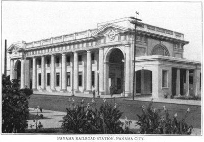
Panama Railroad Station, Panama City


The Panama Railroad  Culebra Station - 1911


The Panama Railroad
Bridge across the Chagres River at Gamboa
 
Panama Railroad Train Crossing Gatun River Bridge


The Panama Railroad Atlantic Terminal Office Building, Cristobal Colon.


The Panama Railroad Atlantic Terminal Office Building, Cristobal Colon.


Passenger Train at the Panama City Station 1927


Panama Railroad Station 1928  


Panama Railroad, broad-gauge locomotive no.51, c.1884 (coll. Illinois Central)


Panama Railroad Train Crossing Central Avenue around 1930


Panama Railroad, passenger train with Alco road switcher no.903, departure Colon in 1974 (Dr. Fritz Stoeckl)