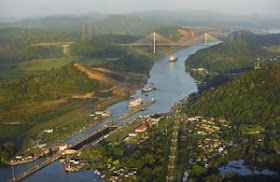
Gaillard Cut


Tour Suggested


The Gaillard Cut, or Culebra Cut, is an artificial valley that cuts through the continental divide in Panama. The cut forms part of the Panama Canal, linking Lake Gatún, and thereby the Atlantic Ocean, to the Gulf of Panama and hence the Pacific Ocean. It is 12.6 km (7.8 mi) from the Pedro Miguel lock on the Pacific side to the Chagres River arm of Lake Gatun, with a water level 26 m (85 ft) above sea level.
Construction of the cut was one of the great engineering feats of its time; the immense effort required to complete it was justified by the great significance of the canal to shipping, and in particular the strategic interests of the United States of America.

Construction

French work

As described in History of the Panama Canal, the excavation of the Culebra Cut was begun by a French venture, led by Ferdinand de Lesseps, which was attempting to build a sea-level canal between the oceans, with a bottom width of 22 metres (72 ft). Digging at Culebra began on January 22, 1881. A combination of disease, underestimation of the problem, and financial difficulties led to the collapse of the French effort, which was bought out by the United States in 1904. The French had excavated some 14,256,000 m³ (18,646,000 cubic yards) of material from the cut, and had lowered the summit from 64 metres (210 ft) above sea level to 59 metres (193 ft), over a relatively narrow width.


American work


The United States took over on May 4, 1904. Under the leadership of John F. Stevens, and later George Washington Goethals, the American effort started work on a wider, but not as deep a cut, as part of a new plan for an elevated lock-based canal, with a bottom width of 91 metres (300 ft); this would require creation of a valley up to 540 metres (a third of a mile) wide at the top. A vast amount of new earthmoving equipment was imported, and a comprehensive system of railways was constructed for the removal of the immense amounts of earthen and rocky spoil.

Major David du Bose Gaillard, of the U.S. Army Corps of Engineers, joined the project at the same time as Goethals, and he was put in charge of the central district of the canal, which was responsible for all of the work between Gatun Lake and the Pedro Miguel locks — most notably, the Culebra Cut. Gaillard brought dedication and quiet, clear-sighted leadership to his difficult, complex task.
The scale of the work was massive. Hundreds of large steam drills bored holes in which were planted tons of dynamite, which blasted the rock of the cut so that it could be excavated by steam shovels. Dozens of spoils trains took the spoil from the shovels to the landfill dumps, about twelve miles (19 km) away. In a typical day, 160 trainloads of material were hauled away from a cut nine miles long (14 km). This workload on the railroads required some skillful co-ordination. At the busiest times, there was a train going inbound or outbound almost every minute.

Six thousand men worked in the cut, drilling holes, placing explosives, controlling steam shovels, and running the dirt trains. They also moved and extended the railroad tracks as the work moved forward. Twice a day work stopped for blasting, and then the steam shovels were moved in to take the loose spoil (dirt and rock) away. More than 600 holes filled with dynamite were fired daily. In all, 60 million pounds (27,000 tonnes) of dynamite were used. In some locations, about 52,000 pounds (23.6 metric tonnes) of dynamite were planted and detonated for a single blast.

Landslides
The excavation of the cut was one of the greatest areas of uncertainty in the creation of the canal, due to the unpredicted large landslides. The International Board of Consulting Engineers had mistakenly decided that the rock would be stable at a height of 73.5 metres with a slope of 1 in 1.5; in practice, the rock began to collapse from that slope at a height of only 19.5 metres. The misjudgment was in part due to unforeseen oxidation of the underlying iron strata due to water infiltration, which caused weakening and eventually a collapse of the strata.

The first and largest major slide occurred in 1907 at Cucaracha. The initial crack was first noted on October 4, 1907, followed by the mass wasting of about 382,000 m³ (500,000 cubic yards) of clay. This slide caused many people to suggest the construction of the Panama Canal would be impossible; Gaillard described the slides as tropical glaciers, made of mud instead of ice. The clay was too soft to be excavated by the steam shovels, and it was therefore largely removed by sluicing it with water from a high level.

After this, the sediment in the upper levels of the cut was removed, resulting in less weight over the weak strata. The slide still continued to cause minor problems after this

Completion

Steam shovels broke through the Culebra Cut in May, 1913. The Americans had lowered the summit of the cut from 59 metres (193 ft) to 12 metres (40 ft) above sea level, at the same time widening it considerably, and they had excavated over 76 million cubic metres (100 million cubic yards) of material. Some 23 million cubic metres (30 million cubic yards) of this material was additional to the planned excavation, having been brought into the cut by the landslides.

Gaillard died from a brain tumor in Baltimore, Maryland, on December 5, 1913, having been promoted to colonel just one month prior, and hence he never saw the opening of the canal in 1914. The Culebra Cut, as it was originally known, was renamed to the Gaillard Cut on April 27, 1915, in his honor

Panama Canal Administration Building


Tour Suggested
More tour options : www.panamatourismtravel.com


The Panama Canal Administration Building was inaugurated on July 15, 1914, exactly a month before the official opening of the Canal. According to records dating back to the construction era, the entire building cost $879,000, a sizeable sum at the time.

The building is at the top of a hill, prominently overlooking the Canal, the town and port of Balboa, and parts of Panama City. The Administration Building serves as the headquarters of the Panama Canal Authority (ACP) and houses administrative offices. Of particular interest to tourists are the Administration Building's colorful murals that adorn the ceiling of the inner rotunda. These murals were painted by New Yorker William B. Van Ingen, who is also known for his murals in the U.S. Library of Congress, and the Philadelphia Mint.

They depict the monumental labor involved in building the Canal through four scenes: the Culebra Cut excavation, the Gatun Dam Spillway construction, the Miraflores locks construction and the building of one of the colossal lock gates. These murals commemorate the efforts, courage, and heroism of the multinational workforce dedicated to building the famous canal that united the world's two greatest oceans.


Construction of the Miraflores Locks

The panel depicted here shows construction of a side wall culvert at Miraflores Locks. The huge locks culverts, that direct the flow of water, are large enough to drive a train through. The murals tell the overall story of the building of the Panama Canal in four main scenes, which show Gaillard Cut at Gold Hill, where the Canal passes through the Continental Divide; the building of the spillway of Gatun Dam, which dams the Chagres River to create the Gatun Lake; construction of a lock miter gate; and the Miraflores Locks near the Pacific entrance to the Canal. The frieze below presents a panorama of the excavation of Gaillard Cut. The power of these vividly portrayed scenes has the effect of linking all who view them in an unbroken chain with those engineering masters and the heroic work force that created the Canal.

Gatun Dam Spillway Construction

Construction of the Gatun Dam spillway is shown here. Gatun Lake was formed by the damming of the Chagres River, and the dam's fourteen spillway gates maintain the lake at 85 feet above sea level. At the time of its formation, Gatun Lake was the largest manmade lake in the world
The Culebra Cut

Excavation through the Continental Divide, shown here, required digging down some 270 feet through the lowest of this mountainous area to form the bottom of the Canal in Gaillard Cut. The Canal's original width in the Cut was 300 feet, and trains were used to haul away some 262 million cubic yards of earth and rock from this area.
Restorer's Remarks: "The Panama Canal murals in the Administration Building rotunda are the masterpiece of their creator, artist William B. Van Ingen. The light, impressionist colors reflect the atmospheric quality of Panama and the bold compositions commemorate in pictorial form, the actual building of the Panama Canal. Over the years, mold and dirt settled on the murals necessitating cleanings in 1929, 1932, 1939, 1960 and 1993. During the 1993 conservation effort, over 22,000 cotton swabs were used to clean the murals of dirt and grime, as well as old overpaint that was covering many areas of the mural, particularly the sky of the frieze. The cleaning was accomplished with a combination of cleaners that removed the grime and old varnish, but did not harm the murals. A few areas of touch-up were needed, though not many, as the murals were in good condition despite previous cleanings. The entire project was documented with video and hundreds of photos, both black and white and color, and an extensive written report was prepared in English and Spanish to serve as a guide for any future restorations.


Canal Lock Gate Under Construction

This panel shows a partially completed lock gate. Steel structure 65 feet wide and 7 feet thick, lock gates vary in height from 47 to 82 feet and weigh from 390 to 730 tons. The Canal uses some 80 of these gate leaves at the various locks. Canal Chief Engineer George W. Goethals is credited with having the foresight to ensure that a record of the monumental labor involved in the building of the Canal was preserved in this art form, so that all who come after might not only marvel at what was accomplished and appreciate its grandeur, but might share in the sense of pride and commitment that this magnificent achievement has always evoked, not only in those who built the waterway, but also in all who have been involved, throughout the years, in its operation and administration.

Goethals chose carefully the person who would be entrusted with this special project, selecting William B. Van Ingen of New York, an outstanding artist who had achieved considerable fame for his murals in the Library of Congress in Washington, D.C. and the U.S. Mint in Philadelphia. Van Ingen agreed to produce the murals at $25 per square foot, which was the way such work was contracted for in those days, and the finished murals cover about 1,000 square feet. Van Ingen and two assistants, C.T. Berry and Ira Remsen, made charcoal sketches of Canal construction activities for the mural during two visits to Panama in 1914, while on the latter of the construction work. Van Ingen then painted the murals on separate panels in his New York studio. The panels were shipped to Panama and installed over a 3-day period in January 1915 under the artist's personal supervision. The paintings have the distinction of being the largest group of murals by an American artist on display outside the United States.

Van Ingen identified completely with the Canal work. In discussing the murals at that time, he said he had become so caught up in the construction effort that he felt that he, too, was a Canal worker. He said, "I forgot I was an artist and had genuine regret at not being entitled to a number and a brass identification badge." According to Van Ingen, his challenge in producing the murals had been how to portray the magnitude of the Canal construction. In explaining his approach to the task, he said, "I tried to compose into one picture the views to be seen from different standpoints, but united in the mind. It enabled me to combine different periods of time in the construction work." Commenting on his perspective in composing the paintings, he added, "Any success the paintings may have had, came, I believe, from an endeavor to see with the eyes of the man in the ditch."

The murals were restored in 1993 by art conservator Anton Rajer, of Madison, Wisconsin, and rededicated in a special ceremony on September 29, 1993.


Goethals Memorial Monument

Tour Suggested


More tour options : www.panamatourismtravel.com


In 1907 US President Theodore Roosevelt appointed George Washington Goethals chief engineer of the Panamal Canal. The building of the Canal had met with many difficulties and delays under previous chiefs. Goethals did much to make operations more efficient throughout the Canal project, with great attention to details large and small. A major part of his success was his particular attention to sanitation and control of disease carrying mosquitos, which greatly reduced incidence of disease and death among Canal workers.

In 1914 Goethals saw the completion of the Canal almost a full year ahead of schedule


Bridge of the Americas


The Bridge of Americas or Puente de las Américas in Spanish, was built in 1962 as a more efficient way for vehicle traffic to travel between land masses on the North and South of the Panama Canal, along the Pan-American Highway.

 
The United States initiated and funded the project, which cost 20 million U.S. dollars at the time. Up until its completion, the only way for vehicles to cross the Panama Canal was by a small swinging road bridge at the Gatun Locks or a swinging road and rail bridge at Miraflores Locks. Both had a very limited capacity. The United States hoped to make it much easier to cross the Panama Canal and to reconnect Colon and Panama City, which were cut off from the rest of their republic.

Building the Bridge of Americas

When the Panama Canal was first built in the early 20th century it was recognized that it would create a physical barrier between Colon and Panama City and the rest of the country. Up until 1942 two ferries shuttled vehicles from one side of the canal to the other and until 1962, when two swinging bridges with limited capacity were added to help move vehicles to either side.

Even back in 1923, the need for a permanent bridge or structure spanning the canal was given priority. Finally in 1955 the Remon-Eisenhower Treaty commissioned the United States to initiate and fund the project.
The Bridge of Americas, which is 5,425 feet long, took three years to build and upon completion stood 384 feet above sea level, leaving a clearance of 200 feet for ships passing below during high tide.

At first it was called the Thatcher Ferry Bridge in honor of the original ferry that helped vehicles cross the canal. Just a decade after the bridge was officially commissioned it was unofficially renamed as the Bridge of Americas, much preferred by the Panamanian government. Only in 1979 was the bridge officially renamed.

The Amador Causeway

For tour option visit www.panamatourismtravel.com


The Amador Causeway is a must see tourist destination located at the southern entrance of the Panama Canal near Panama City
.
Tour Suggestion

What is the Amador Causeway?

For those unfamiliar with this Panama landmark, the Amador Causeway is both a roadway and a walking path that connects Panama’s mainland to four small islands: Naso, Culebra, Perico and Flamenco.

It is a beautiful and picturesque causeway that captures the attention of both visitors enjoying Panama vacations and locals. The roads are lined with palm trees and feature magnificent views of the Panama Canal including Panama City’s skyline, the Bridge of Americas and Panama Bay.
 

Building Panama’s Amador Causeway

The Calzada de Amador, known as the Causeway, was built around the same time as the Panama Canal in 1903.

The original purpose of the causeway was to prevent sedimentation in the Port of Balboa which, if left untouched, eventually would clog the southern (Pacific) entrance into the Panama Canal. The causeway was also designed as a breakwater to protect the entrance.

Because it was built at the same time as the Panama Canal, the causeway was made from 1,250 million cubic yards of rock excavated from Culebra Cut.

The United States investment in the development of Panama and in particular the Panama Canal put the Americans at a beneficial position; the United States controlled the Amador Causeway from 1915 until World War 2. The United States used the area as a military base and restricted access to just Americans. During both World Wars the U.S. Military used the Causeway as a powerful defense system.
Only in September of 1996 did the Amador Causeway become the property of Panama. At this point, Panamanians had complete access to the area.

Things to Do Along the Amador Causeway

 
In the last 15 years the Amador Causeway area has been redeveloped to attract locals and tourists. Vehicle traffic is restricted to one side of the causeway leaving lots of room for foot traffic to access the Causeway. Many visitors who enjoy Panama vacations also enjoy a leisure walk, jog, bike, skate or roller-blade along the Amador Causeway between all four islands. Others enjoy relaxing along the beaches and taking swims in the refreshing Pacific waters. From the Causeway, anyone can watch Panama cruises come and go through the Panama Canal.

Panama’s Amador Causeway provides wonderful views of the Bridge of Americas, Balboa Yacht Club and Panama Bay. Several projects near the Amador include a cruise port, a marina, the Fuerte Amador Shopping and Restaurant Plaza and the Fiagli Convention Centers. Numerous Panama hotels and resorts have popped up in the area as well.

Also worth mentioning is the Marin Exhibition Center of the Smithsonian Tropical Research Institute (STRI) which lets visitors get a close up look at creatures native to the country of Panama.


Panama Weather and Climate

In addition to being renowned for its picturesque beaches and beautiful rainforests, Panama is also known for the finest tropical climate in the Caribbean. Unlike other Central American countries, which usually receive extremes of heat and rainfall, Panama weather is pleasant and inviting year round. Because of an overall stable temperature graph through all months, the seasons in Panama are usually categorized on the basis of rainfall.

Rainy Season

The rainy season in Panama extends from mid April to mid December. The minimum and maximum temperature in this season falls between 21 and 32 degrees Celsius. Nights tend to be much cooler than the days with the temperature dropping considerably after dusk. The rainfall received during the rainy season varies with location, with the Caribbean coast experiencing much heavier thundershowers than the Pacific coast. The average monthly precipitation recorded in Panama over the last few years has been 40 inches, with the maximum rainfall experienced in the month of October.

Dry Season

The dry season in Panama usually extends from mid December to mid March. The minimum and maximum temperature in this season falls between 24 and 29 degrees Celsius. It is common in some parts of Panama to experience light showers even in the dry season. The region also experiences relatively lower humidity levels during these three months. The days are usually bright and sunny and the nights are cool and pleasant.

Panama Located and Size


Panama is located in Central America between Costa Rica to the north and Colombia to the south. It is at the southern end of the Central American isthmus (a narrow piece of land that connects two larger land areas) and forms the land bridge between North and South America.


The nation is S-shaped and runs from east to west with a length of 772 kilometers (480 miles) and a width that varies from 60 to 177 kilometers (37 to 110 miles).
Panama has an area of 77,381 square kilometers (29,762 square miles) which makes it slightly smaller than South Carolina. This area consists of 75,990 square kilometers (29,340 square miles) of land and 2,210 square kilometers (853 square miles) of water.

The nation borders the Caribbean Sea on one coast and the Pacific Ocean on the other. The 80-kilometer (50-mile) Panama Canal cuts the nation in half and joins the Atlantic and Pacific Oceans. The combined coastlines of Panama are 2,857 kilometers (1,786 miles) long. The nation's border with Costa Rica is 330 kilometers (205 miles), and its border with Colombia is 225 kilometers (140 miles) in length.


A Pictorical History of the Panama Railroad


Railway Workers living in rail cars


Construction, Panama Railroad offices


Panama Railroad Station, Panama City


The Panama Railroad  Culebra Station - 1911


The Panama Railroad
Bridge across the Chagres River at Gamboa
 
Panama Railroad Train Crossing Gatun River Bridge


The Panama Railroad Atlantic Terminal Office Building, Cristobal Colon.


The Panama Railroad Atlantic Terminal Office Building, Cristobal Colon.


Passenger Train at the Panama City Station 1927


Panama Railroad Station 1928  


Panama Railroad, broad-gauge locomotive no.51, c.1884 (coll. Illinois Central)


Panama Railroad Train Crossing Central Avenue around 1930


Panama Railroad, passenger train with Alco road switcher no.903, departure Colon in 1974 (Dr. Fritz Stoeckl)